The real story of Canada’s Atlantic harbors isn’t found on postcards, but in the unseen forces of geography, conflict, and commerce that built and sometimes broke them.
- Each port’s identity was forged by its unique “strategic DNA”—military might for Halifax, mercantile hustle for Lunenburg.
- The world’s highest tides weren’t just a spectacle; they were an engineering challenge that determined a harbor’s survival.
Recommendation: To truly understand these places, look past the colorful facades and see the history written in the tide lines, view planes, and shipping lanes.
The image of Canada’s Maritime provinces is often painted in broad, romantic strokes: brightly coloured houses clinging to rocky shores, the smell of salt and fried fish in the air, and the iconic silhouette of a schooner against the sunset. For many road trippers and history buffs, a journey through Nova Scotia and Newfoundland is a quest for these picture-perfect moments. You might plan to walk the Halifax waterfront, eat a lobster roll in Lunenburg, and snap a photo of a lighthouse. These are wonderful experiences, but they only scratch the surface.
Most guides will give you a checklist of sights, but they rarely explain the ‘why’. Why does Halifax feel like a fortress while Lunenburg feels like a merchant’s ledger? Why did some harbors thrive while others, just a few kilometers away, were swallowed by silt and time? The typical answer involves vague references to “rich history” and “fishing heritage.” But what if the key to truly understanding these coastal towns isn’t just in what you can see, but in the invisible forces that shaped them?
This guide offers a different perspective. We’ll move beyond the simple ‘what to see’ and delve into the ‘why it’s there’. Our journey is guided by a central idea: that every historic harbor possesses a unique strategic DNA, a code written by the powerful interplay of geography, military conflict, and commercial ambition. We will explore how the relentless tides of the Bay of Fundy were not just a spectacle but a formidable engineering challenge, how naval wars fought centuries ago still dictate the skyline of a modern city, and how the global appetite for a single crustacean shapes an entire region’s economy.
By understanding these underlying forces, your tour of the Maritimes will transform from a simple sightseeing trip into a deep, compelling narrative. You will learn to read the landscape like a historian, seeing the stories etched into the very layout of the streets, the architecture of the buildings, and the rhythm of the tides. This is your guide to tracing the authentic naval and maritime soul of Atlantic Canada.
This article will guide you through the essential stories and strategic insights needed to truly appreciate the region’s coastal heritage. We’ll compare iconic ports, uncover common travel mistakes, and reveal the hidden logic behind everything from local architecture to the price of seafood.
Summary: A Historian’s Guide to Canada’s Atlantic Harbors
- How to Navigate Halifax’s Waterfront History in One Afternoon?
- Lunenburg vs. St. John’s: Which Harbor Offers Better History Tours?
- Missing the Tide Changes at Bay of Fundy Harbors: A Scheduling Error
- Why Historic Preservation Rules Limit Modern Construction in These Zones?
- When to Visit to Catch the Tall Ships Festivals in the Maritimes?
- Active vs. Decommissioned Lighthouses: Difference in Guest Experience and Noise?
- Why Lobster Is Cheaper in May/June vs. December in the Maritimes?
- Driving Route des Navigateurs: Exploring the St. Lawrence South Shore
How to Navigate Halifax’s Waterfront History in One Afternoon?
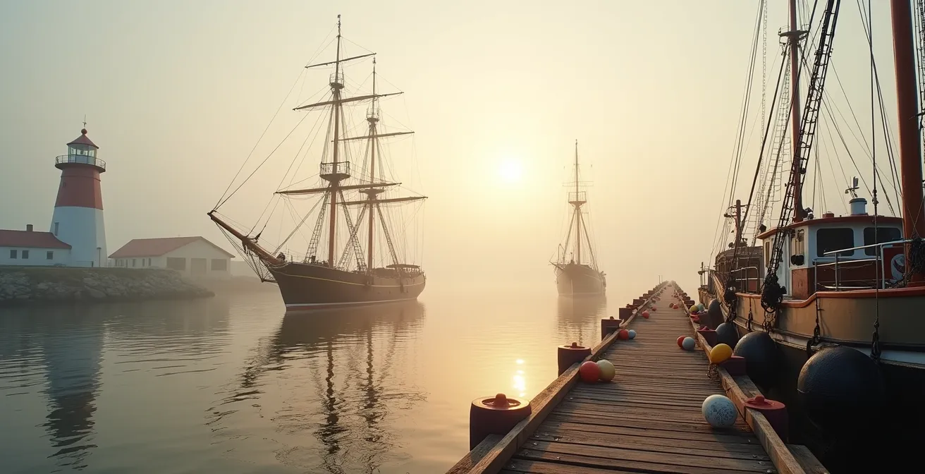
Halifax is not just another pretty harbor; it is a fortress forged by empire and war. Its strategic DNA is overwhelmingly military. The city was founded in 1749 by the British precisely for its deep, ice-free, and highly defensible harbor, a strategic counterweight to the French fortress of Louisbourg. To spend an afternoon here is to walk through layers of naval history, where the ghosts of warships and convoys are ever-present. Unlike purely mercantile ports, Halifax’s development has always been tied to its role as a geopolitical chokepoint for the Royal Navy and, later, the Royal Canadian Navy.
This military past is palpable everywhere. The Halifax Explosion of 1917, a pivotal moment in the city’s history, is a stark reminder of this reality. As detailed in a permanent exhibit at the Maritime Museum of the Atlantic, the catastrophic collision between the French munitions ship SS Mont-Blanc and the Norwegian relief vessel SS Imo occurred because the harbor was a critical global logistics hub during World War I. The explosion, the largest man-made blast before the atomic age, instantly cemented the port’s high-stakes role in global conflict.
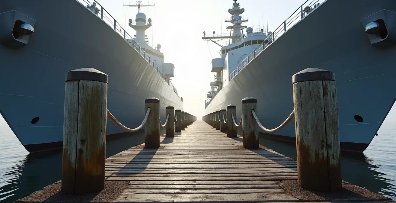
As this image suggests, the dialogue between past and present is constant. The weathered wooden piers that once moored sailing frigates now sit in the shadow of modern warships. To truly grasp this in a short time, you must follow the path of a sailor or an immigrant, understanding the harbor as a place of departure, arrival, and defense. The city’s very layout is a testament to this, with sightlines and fortifications dictating its growth for centuries. An afternoon here is an immersion in the living heritage of Canada’s most important naval port.
Your Action Plan: A WWII Convoy Sailor’s Path
- Start at the Maritime Museum of the Atlantic to explore Canada’s largest collection of maritime artifacts and the CSS Acadia steamship.
- Walk along the Lower Water Street boardwalk, following the historic convoy departure route used during the Battle of the Atlantic.
- Visit the Canadian Museum of Immigration at Pier 21 to understand the port’s role as Canada’s ‘Ellis Island’ and a gateway for millions.
- Stop at the Halifax Explosion memorial site in the city’s North End to learn about the 1917 collision between the Mont-Blanc and Imo.
- End at the Sailor’s Memorial overlooking the harbor for a quiet reflection on the sacrifices made during the Battle of the Atlantic.
Lunenburg vs. St. John’s: Which Harbor Offers Better History Tours?
Choosing between Lunenburg and St. John’s is less about which is “better” and more about understanding their fundamentally different origins. This is a classic case of contrasting strategic DNA. Lunenburg is the quintessential mercantile port, built on the wealth of the Grand Banks fishery and the skill of its shipwrights. St. John’s, by contrast, is a rugged military and strategic outpost, its history defined by its command of the North Atlantic narrows and its role as the first line of defense for a continent.
Lunenburg, a UNESCO World Heritage Site, feels like a living museum. As Halifax tour guide Mel Z. notes, “Lunenburg is truly a walking town and some hills with everything centrally located and just a short distance from one another.” This compact, planned layout was designed for efficiency in the Age of Sail. A tour here is an immersion into the world of the Bluenose, of dory fishermen, and of the trading families whose ornate homes still line the streets. It’s a story of commerce and craftsmanship preserved in amber.
St. John’s offers a grittier, more layered experience. While it lacks the pristine, color-coded preservation of Lunenburg, its history is visceral. From the top of Signal Hill, where Marconi received the first transatlantic wireless signal, you understand its strategic importance. The port is a working, modern harbor that has been continuously fought over for centuries by the French and English. Its tours delve into military history, the hardscrabble life of a garrison town, and its deep, complex Indigenous history with Beothuk and Mi’kmaq peoples. The experience is less “living museum” and more “living city,” where history mingles with the vibrant, contemporary culture of George Street.
This table highlights the core differences in their historical offerings, helping you choose the experience that best fits your interests.
| Aspect | Lunenburg | St. John’s |
|---|---|---|
| UNESCO Status | World Heritage Site since 1995 | No UNESCO designation |
| Historical Focus | Mercantile/Fishing (Bluenose, Age of Sail) | Military/Strategic (Signal Hill, Atlantic narrows) |
| Preservation | 70% of original 18th-19th century colonial buildings remain preserved | Working port with modern development |
| Tour Experience | ‘Living museum’ atmosphere | Active city with George Street culture |
| Indigenous History | Limited Mi’kmaq interpretation | Beothuk memorial sites, active Mi’kmaq presence |
Missing the Tide Changes at Bay of Fundy Harbors: A Scheduling Error
One of the biggest mistakes a visitor can make in the Maritimes is treating the Bay of Fundy tides as a static attraction. To see the Hopewell Rocks at just high tide or just low tide is to miss the point entirely. The story of this region is written in the movement of water. The Bay of Fundy is not merely a place; it’s a colossal hydraulic engine. It experiences the planet’s most extreme tides, with a range that can exceed 16 meters (52 feet) in some areas. This isn’t just a fun fact; it’s the single most powerful geographic force shaping life and history along its coast.
For centuries, this twice-daily surge of 160 billion tonnes of water has been both a creator and a destroyer. At locations like Hopewell Rocks, it carves the iconic “flowerpot” formations, allowing you to walk on the ocean floor and, just six hours later, kayak around the tops of what were islands. But for historic harbors, this force required immense respect and clever tidal engineering. Ports like Annapolis Royal, once the capital of Nova Scotia, struggled and ultimately declined as the powerful tides deposited massive amounts of silt, choking their harbor. Conversely, other communities harnessed the tides for shipbuilding, using the extreme low tide to work on the hulls of massive wooden ships built right on the shore.
To truly appreciate this, your schedule must be dictated by the tide tables, not the clock. Planning a visit requires seeing a single location at both its high and low water marks. Only then can you grasp the sheer scale of the transformation and understand why some settlements thrived by mastering this rhythm, while others were simply washed away by it. To miss the change is to miss the very pulse of the Bay of Fundy.
To make the most of your visit, consider these essential planning tips:
- Check tide tables 2-3 months in advance for optimal viewing times at specific locations like Hopewell Rocks or Halls Harbour.
- For an adrenaline rush, book tidal bore rafting experiences on the Shubenacadie River during a spring tide for maximum wave height.
- Visit shipbuilding heritage sites like those in St. Martins, New Brunswick, at low tide to see the exposed wooden supports where vessels were constructed.
- Plan any visit to Hopewell Rocks to straddle the low tide mark, allowing at least 3 hours before and after to explore the ocean floor safely.
- Schedule a tour of the Minas Basin to witness the incredible Acadian dykelands, a massive earthworks system built to reclaim farmland from the powerful tides.
Why Historic Preservation Rules Limit Modern Construction in These Zones?
As you wander through towns like Lunenburg or the historic districts of Halifax, you might notice a distinct lack of modern high-rises or glass-and-steel facades. This is no accident. It’s the result of rigorous historic preservation rules, often a source of tension between maintaining a town’s character and allowing for modern development. These regulations are not about freezing a town in time, but about managing the evolution of a living heritage. The goal is to ensure that the “story” told by the architecture and layout remains legible for future generations.
Lunenburg is the prime example. Its status as a UNESCO World Heritage site is contingent on maintaining the integrity of its original layout and wooden architecture, which reflects a model British colonial settlement. This designation comes with strict bylaws that govern everything from paint colours to window designs, ensuring that new construction is either invisible or highly compatible with the existing 18th and 19th-century aesthetic. It’s a key reason why an astonishing 70% of its original colonial-era buildings are still standing and in use.
In a larger, more dynamic city like Halifax, these rules take a different form. Here, the challenge is balancing a booming downtown with priceless historic assets. A fascinating example is the city’s “View Planes” legislation. These bylaws are specifically designed to protect the sightlines from the top of Citadel Hill to key points in the harbor. One of the most famous protected views is that of the Old Town Clock, a Palladian-style structure commissioned by Prince Edward in 1800. The law prevents any new building from obstructing the view of this clock from the fortress above. This is not just about aesthetics; it’s about preserving the strategic sightline that was the very reason for the clock’s, and the city’s, placement. These rules are a modern legal framework designed to protect the physical manifestation of a city’s strategic DNA.
When to Visit to Catch the Tall Ships Festivals in the Maritimes?
For any lover of maritime history, the sight of a harbor full of tall ships, their masts a forest against the sky, is an unforgettable experience. These festivals are a vibrant celebration of the Age of Sail, bringing the region’s history to life. While large, organized “Tall Ships” events happen periodically (often every few years), you don’t need to wait for a major international gathering to immerse yourself in this world. The entire summer season in the Maritimes, from late June to early September, is dotted with opportunities to see and even sail on these magnificent vessels.
The key is to look beyond a single event and see the season as a continuous festival. The queen of the coast is the Bluenose II, a faithful replica of the legendary fishing and racing schooner. Docked in her home port of Lunenburg, she offers daily deck tours and harbor cruises throughout the summer. Seeing her iconic sails against the backdrop of the colourful town is a quintessential Nova Scotian moment. The original Bluenose was more than a ship; it was a symbol of national pride, remaining undefeated in the International Fisherman’s Race for 17 years. This legacy is the heart and soul of every schooner race and classic boat festival in the region.

To plan your visit, think in terms of experiences rather than dates. Do you want to watch schooners race in a competitive but friendly regatta? Head to Chester Race Week in early August. Are you interested in the craftsmanship of traditional wooden boats? The Mahone Bay Classic Boat Festival in late July is a must-see. For those with a true sense of adventure, organizations like the Canadian Sail Training Association offer the chance to book a berth on a training voyage aboard a vessel like the ‘Picton Castle’, learning the ropes just as sailors did centuries ago. The best time to visit is any time in the summer, with a plan to intercept these floating pieces of history as they move along the coast.
Active vs. Decommissioned Lighthouses: Difference in Guest Experience and Noise?
The lighthouses dotting the Atlantic coast are powerful symbols of maritime safety and heritage, but not all offer the same experience. The primary distinction lies in whether a lighthouse is an active, automated aid to navigation or a decommissioned historic site. This determines everything from the noise level to the style of accommodation available, and understanding the difference is crucial for setting the right expectations.
An active lighthouse is a working piece of infrastructure managed by the Canadian Coast Guard. While iconic, the romance can be interrupted by reality. Modern lighthouses are automated, featuring powerful LED lights and, most importantly, automated foghorns. These horns can blast at volumes up to 120 decibels—as loud as a jet engine at takeoff—at regular intervals during foggy weather. Access to the lantern room is almost always restricted for safety and security reasons. The iconic Peggy’s Cove lighthouse is a perfect example; it remains one of the most photographed locations in Canada and is a vital, active aid to navigation, but you can’t go inside or stay overnight. It represents a transition, maintaining its historic form while operating with modern, automated technology.
A decommissioned lighthouse, on the other hand, offers a much more immersive historical experience. These sites are often managed by local heritage societies or Parks Canada. With the navigational equipment removed or preserved for display (like a beautiful old Fresnel lens), the focus shifts to preservation and interpretation. The keeper’s house is often converted into a museum, an inn, or a bed & breakfast. Staying in a place like the West Point Lighthouse on PEI means you have full access to the keeper’s quarters, furnished in a period style, and can experience the solitude and natural ocean sounds without the interruption of a foghorn. It’s a chance to step back in time and experience the isolated life of a lighthouse keeper.
| Feature | Active Lighthouses | Decommissioned Lighthouses |
|---|---|---|
| Sound Level | Automated foghorn (up to 120 decibels) | Natural ocean sounds only |
| Accommodation Style | Limited access, Coast Guard controlled | Full keeper’s house access (e.g., West Point, PEI) |
| Historical Atmosphere | Modern automated equipment visible | Period furnishings, original keeper artifacts |
| Navigation Systems | LED lights, radio beacons, GPS aids | Historic Fresnel lenses (display only) |
| Management | Canadian Coast Guard centralized control | Parks Canada or heritage societies |
Why Lobster Is Cheaper in May/June vs. December in the Maritimes?
For many visitors, a trip to the Maritimes is synonymous with a fresh lobster dinner. But the price and availability of this celebrated crustacean can fluctuate wildly, leaving many confused. The answer isn’t market manipulation; it’s a perfect example of economic tides, where cost is directly tied to the strict, seasonal fishing regulations governed by the Department of Fisheries and Oceans (DFO) and the natural life cycle of the lobster.
The Maritime provinces are the heart of Canada’s seafood industry, which generates over $2.5 billion CAD annually in seafood exports, with lobster being the crown jewel. The fishing grounds are divided into dozens of Lobster Fishing Areas (LFAs), and each LFA has a strictly enforced fishing season. The largest and most lucrative season, off the coast of Southwestern Nova Scotia (LFA 33 & 34), runs from the last Monday in November to May 31st. This means that in the spring, particularly May, the supply is at its absolute peak as fishermen rush to fill their quotas before the season closes. This abundance drives prices down, making May and early June the best time to get a “market price” lobster at a seaside shack.
Conversely, in December, while the season has just opened, demand skyrockets due to the holidays. International exports for Christmas and New Year’s celebrations in Europe and Asia put a massive strain on the early-season supply, causing prices to spike. This is a fascinating transformation for a creature that was once considered “prison food” in the 18th and 19th centuries. The fishing industry, a cornerstone of the region since John Cabot’s voyages in 1497, has seen lobster evolve from poverty fare to a luxury export, thanks in large part to the development of canning technology in the region’s ports. So when you’re enjoying your lobster, you’re not just eating a meal; you’re participating in a multi-billion dollar global industry dictated by the rhythm of the ocean and the calendar.
Key Takeaways
- A harbor’s identity is defined by its “Strategic DNA”—whether it was built for military control (Halifax) or commercial trade (Lunenburg).
- The Bay of Fundy’s extreme tides were a powerful engineering force that dictated the success or failure of historic ports.
- Preservation rules, like Halifax’s “View Planes,” are modern tools used to protect the historical and strategic sightlines that defined a city’s origin.
Driving Route des Navigateurs: Exploring the St. Lawrence South Shore
While often seen as a scenic Quebecois drive, the Route des Navigateurs along the south shore of the St. Lawrence River is also the final chapter in the story of Atlantic Canada’s naval dominance. To drive this route is to trace the path of a historic invasion, understanding the river not as a boundary, but as a highway for military power. The entire strategic history of the Maritimes culminates in this river, which served as the ultimate geopolitical chokepoint for control of North America.
For centuries, the French controlled this artery, supplying their colonial empire from Quebec City and Montreal. The British, based in their Atlantic fortress of Halifax, knew that to conquer the continent, they had to control the river. As a historical analysis from the Canadian government points out, “British dominance from Halifax was the key that allowed the Royal Navy, under James Wolfe, to successfully push up the St. Lawrence and capture Quebec in 1759, changing Canada forever.” Halifax was the key that unlocked the door to the continent, and the St. Lawrence was the hallway.
British dominance from Halifax was the key that allowed the Royal Navy, under James Wolfe, to successfully push up the St. Lawrence and capture Quebec in 1759, changing Canada forever.
– Maritime History Analysis, Atlantic Canada Naval Heritage
As you drive the Route des Navigateurs, you can see this history everywhere if you know where to look. The Pointe-au-Père Maritime Historic Site commemorates the Battle of the St. Lawrence, a lesser-known but critical U-boat campaign during WWII. The Davie Shipyard in Lévis, across from Quebec City, has been building warships for centuries. The placement of lighthouses, old shore battery positions, and museums all tell a story of riverine defense and control. This drive is the perfect epilogue to a tour of the Maritimes, connecting the naval power projected from Atlantic harbors directly to the event that sealed the fate of a nation.
Now that you can see beyond the colourful facades and understand the deep forces that shaped these shores, your journey through Atlantic Canada will be immeasurably richer. Plan your trip not just by the map, but by the stories, the tides, and the strategic legacy etched into the landscape.