In summary:
- True safety on the Trans-Canada Highway comes from mastering logistics, not just avoiding wildlife.
- Plan fuel stops strategically around provincial borders to manage significant price differences.
- Be aware of specific high-risk zones like Northern Ontario’s two-lane sections and winter closures in Rogers Pass.
- Use official provincial resources (like DriveBC, 511 Alberta) to get real-time data on construction and closures.
- Understand that “boondocking” is increasingly restricted; have a backup plan for overnight stays in RVs.
The idea of driving the Trans-Canada Highway conjures images of majestic mountains, vast prairies, and the rugged coastline of the Canadian Shield. It’s a bucket-list journey for many, a rite of passage that stitches the country together with asphalt. Most guides will give you the standard advice: check your tires, watch for moose, and pack for all seasons. While that’s not wrong, any seasoned driver who has spent weeks on this road will tell you that true safety isn’t just about what you do behind the wheel—it’s about mastering the hidden logistical challenges that can derail a trip long before you see a mountain or a moose.
The real risks on a journey of this scale are rooted in planning and preparation. Running low on fuel in a 150-kilometre gap between stations, getting stuck for hours in a construction zone, or finding your planned route through the Rockies is closed for avalanche control—these are the frustrating and potentially dangerous realities the glossy travel brochures leave out. The difference between a successful crossing and a stressful ordeal lies in understanding this logistical friction and planning for it with discipline.
But what if you could approach this drive not as a tourist, but as a veteran? What if the key to safety wasn’t just reacting to the road, but proactively managing the variables of fuel costs, route choices, and seasonal hazards? This guide is built on that premise. We will move beyond the basics and dive into the practical, on-the-ground knowledge you need to navigate the entire 7,476-kilometre expanse with confidence. We’ll cover strategic fuelling, navigating infamous road sections, and understanding the unwritten rules of the road that keep you safe, solvent, and on schedule.
This article breaks down the essential logistical knowledge you need for a safe and efficient journey across the country. The following sections provide a detailed roadmap, covering everything from provincial fuel tax strategies to navigating critical mountain passes, ensuring you’re prepared for the real challenges of the Trans-Canada Highway.
Summary: Driving the Trans-Canada Highway: Crossing the Continent Safely
- How to budget for gas across 5 different provincial tax zones?
- The danger of single-lane passing zones in Northern Ontario
- Northern Route vs. Southern Route: which is faster for cross-country travel?
- Why construction season delays travel by hours in summer months?
- When to avoid Roger’s Pass due to avalanche control closures?
- Range anxiety risks on the Trans-Canada Highway gaps: planning buffer stops
- Why “boondocking” in Wal-Mart parking lots is increasingly banned in tourist towns?
- Driving Rocky Mountain Loops: The Golden Triangle Itinerary Guide
How to Budget for Gas Across 5 Different Provincial Tax Zones?
One of the biggest variable costs on a cross-country trip is fuel, and the price you pay can change dramatically the moment you cross a provincial border. This isn’t just about market fluctuations; it’s about provincial taxes. A seasoned driver doesn’t just fill up when the tank is empty; they practice zone arbitrage, strategically planning fuel stops to take advantage of these differences. Ignoring this can easily add hundreds of dollars to your trip budget.
The most significant price jump is often when heading west from Alberta into British Columbia. The difference can be as much as 20 to 30 cents per litre. Therefore, the cardinal rule is to fill your tank completely in Alberta before crossing into B.C. The same logic applies at the Alberta/Saskatchewan border; topping up in a town like Lloydminster, which straddles the border and benefits from Alberta’s lower tax rate, is a common practice for long-haul drivers. Government data confirms this wide variance, showing that across the country, average gasoline prices vary from $1.366 to $1.938 per litre depending on the province and region. This highlights that your fuelling strategy is a critical part of your budget management.
Your plan should involve using apps like GasBuddy to scout prices ahead of time, especially near borders. It’s also crucial to be aware that remote stations, particularly in Northern Ontario or the mountains, can have significantly higher prices. Sometimes paying a premium is unavoidable, but with a little planning, you can minimize those instances and control one of the most significant expenses of your journey.
The Danger of Single-Lane Passing Zones in Northern Ontario
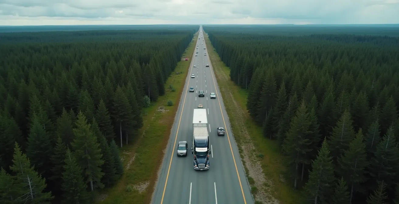
The stretch of the Trans-Canada Highway through Northern Ontario is legendary for its rugged beauty, but it’s also infamous among drivers for its infrastructure challenges. For hundreds of kilometres, the highway narrows to a two-lane road with limited shoulders, winding through the granite of the Canadian Shield. The most significant risk here isn’t wildlife; it’s the other drivers. The lack of passing lanes creates long convoys behind slower-moving trucks and RVs, testing the patience of everyone on the road. This frustration leads to high-risk, head-on passing attempts in short, designated zones, which are a major cause of serious collisions.
This is not an empty warning; the road’s design itself creates what veterans call logistical friction. You are forced to adapt to the pace of the slowest vehicle, and any attempt to gain time is fraught with danger. The isolation of this region means that emergency response times can be long, amplifying the consequence of any mistake. The visual of a single lane of cars tucked behind a transport truck, with no safe way to pass for miles, is the defining image of this part of the journey.
Recognizing this inherent danger, authorities are beginning to implement changes. The province is piloting a roadway design that has proven effective in Europe for decades, demonstrating a commitment to improving safety on this critical corridor.
Case Study: The 2+1 Roadway Pilot
To address the high rate of head-on collisions, a pilot project is underway on Highway 11 north of North Bay, introducing North America’s first 2+1 roadway. This design, used successfully in countries like Sweden since the 1980s, features a three-lane highway where the centre passing lane alternates direction every two to five kilometres, separated by a median barrier. A recent report on the project notes that this configuration significantly improves traffic flow and safety by providing dedicated, protected passing opportunities and eliminating the risk of dangerous head-on passing manoeuvres.
Until these upgrades are widespread, the only safe strategy is route discipline. Accept the slower pace, maintain a safe following distance, and never take a chance on a questionable pass. Your schedule is less important than your arrival.
Northern Route vs. Southern Route: Which Is Faster for Cross-Country Travel?
When planning a cross-country drive, you have a fundamental choice to make: stick to the all-Canadian route (Highway 17 through Northern Ontario) or dip south of the border and use the U.S. Interstate system. The “right” choice depends on your priorities: speed and convenience versus a purely Canadian experience. Many commercial truckers and time-crunched movers opt for the southern route, a fact that speaks volumes about the efficiency of the U.S. system.
As one source plainly puts it, “Another example is that much long-distance traffic between Western and Eastern Canada will drive south into the United States and use the Interstate Highway System, rather than the Trans-Canada Highway through Northern Ontario.” This isn’t about patriotism; it’s a practical calculation of time, fuel, and road quality. The U.S. Interstates are multi-lane highways designed for high-speed travel, with more frequent services and generally better maintenance. The all-Canadian route, while scenic, is plagued by the two-lane bottlenecks and construction delays we’ve discussed.
However, the U.S. route introduces its own complexities, namely a border crossing. This requires passports for all travellers and can involve unpredictable delays. You’ll also need to consider cell phone roaming charges and currency exchange. The choice comes down to a trade-off, as a direct comparison of the routes makes clear.
| Factor | Northern Route (All-Canadian) | Southern Route (via US) |
|---|---|---|
| Distance | 7,476 km total | Shorter by ~500km |
| Infrastructure | Two-lane sections, construction delays | Interstate highways, better maintained |
| Border Requirements | None | Passports, potential delays |
| Cell Coverage | Sporadic in Northern Ontario | Better coverage, roaming charges |
| Fuel Availability | 60-100 miles between stations | More frequent stops |
| Scenery | Canadian Shield, pristine wilderness | US midwest, less dramatic |
Ultimately, if your goal is the experience of seeing Canada from coast to coast, the northern route is the only real option. If your priority is moving people or goods as efficiently as possible, the southern detour is a strategy that professional drivers use every day for a reason.
Why Construction Season Delays Travel by Hours in Summer Months?
In a country with a harsh winter, the window for road repair is short and intense. For drivers on the Trans-Canada Highway, this means that summer—the peak travel season—is also peak construction season. From B.C. to the Maritimes, you will encounter lane closures, pilot cars, and complete stoppages. These aren’t minor inconveniences; in remote areas, a single construction zone can add hours to your travel day. This is a primary source of logistical friction and a major test of any driver’s patience.
The sheer scale of the investment in highway maintenance explains the prevalence of these delays. For example, in a single year, Ontario is spending over $616 million on highway infrastructure, much of it concentrated on these northern routes during the summer months. While essential for long-term safety, it creates a short-term nightmare for travellers. Getting stuck in a 10-kilometre-long lineup, engine off, in the middle of the Canadian Shield with no cell service is an experience you want to avoid.
Fortunately, you are not driving blind. Every province maintains a robust system for reporting road conditions in real-time. The most critical part of your daily routine on the road should be checking these resources before you even start the engine. This allows you to anticipate major delays, adjust your departure time, or in some cases, choose an alternate route. Having this digital toolkit is non-negotiable for an efficient trip.
Canadian Driver’s Digital Toolkit for Construction Updates
- Check DriveBC.ca for British Columbia road conditions before departure.
- Monitor 511 Alberta for real-time construction and closure updates.
- Review Highway Hotline Saskatchewan for pilot car schedules.
- Visit Ontario 511 for Northern Ontario construction zones.
- Subscribe to Québec 511 alerts for Autoroute construction notifications.
Treat construction season as a given. The only way to manage it is with information. A five-minute check in the morning can easily save you two hours on the road. It’s the simplest form of buffer planning you can practice.
When to Avoid Roger’s Pass Due to Avalanche Control Closures?
Of all the mountain passes on the Trans-Canada Highway, none commands more respect than Rogers Pass. Winding through the spectacular but volatile Selkirk Mountains of British Columbia, this 135-kilometre stretch is a marvel of engineering. It’s also one of the most active avalanche zones in the world. To keep the highway safe, Parks Canada and the B.C. Ministry of Transportation run an extensive avalanche control program from November to April. This involves proactively triggering controlled avalanches, which requires closing the highway, often with little notice.
These closures are most common in the early morning hours, but they can happen anytime. For a driver, this means a trip through the pass in winter is a calculated risk. You must be prepared for the possibility of a lengthy delay or the need to take a significant detour. The primary alternative, the “Golden Triangle” route via Highways 95 and 93 through Radium Hot Springs, is a beautiful drive but adds at least 1.5 to 2 hours to your journey. This is a perfect example of where buffer planning for time is not just a good idea, but an absolute necessity.
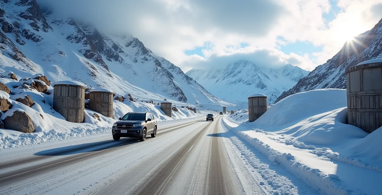
Furthermore, the pass has mandatory winter tire regulations. From October 1st to April 30th, all vehicles must be equipped with proper winter tires (marked with the M+S or three-peaked mountain and snowflake symbol). Police actively enforce this, and being turned back for improper equipment is a frustrating and entirely avoidable delay.
Your Safety Checklist for Rogers Pass
- Points of contact: Monitor Parks Canada’s daily avalanche bulletin and DriveBC.ca from November to April.
- Collecte: Carry emergency supplies, including extra food, water, and warm blankets, in case of unexpected, multi-hour closures.
- Coherence: Ensure your vehicle has approved winter tires (M+S or snowflake symbol) between October 1 and April 30. No exceptions.
- Mémorabilité/émotion: Know your primary detour. The Golden Triangle route (Hwy 95/93 via Radium Hot Springs) adds 1.5-2 hours.
- Plan d’intégration: Plan your travel through the pass to avoid the early morning hours when most control work typically occurs.
Navigating Rogers Pass in winter is the ultimate test of a driver’s preparation. It requires respect for the mountains and strict adherence to the rules—both official and unwritten.
Range Anxiety Risks on the Trans-Canada Highway Gaps: Planning Buffer Stops
While driving through the populated corridors of southern Canada, gas stations are plentiful. But on the long, isolated stretches of the Trans-Canada, particularly across Northern Ontario, services become sparse. Here, range anxiety is a very real concern. On some sections, like the gaps between Wawa and Marathon or Ignace and Shabaqua, gas stations are typically spaced 60 to 100 miles (100 to 160 km) apart. This is where buffer planning becomes a critical survival skill.
A veteran driver lives by the “half-tank rule” in these areas: when your gauge hits 50%, you start actively looking for the next fuel stop. You never pass a gas station assuming another one is just down the road. This disciplined approach provides a crucial buffer against the unexpected—a station that has closed for the day, run out of fuel, or has a power outage. The extra time it takes to stop more frequently is insignificant compared to the time and stress of running out of fuel in a cellular dead zone.
For those driving electric vehicles, this planning is even more critical. Cold weather can reduce an EV’s range by 30-40%, so that buffer needs to be even larger. For both gas and electric vehicles, simple maintenance like ensuring proper tire pressure can have a noticeable impact on efficiency, stretching every litre or kilowatt-hour a little further. For extreme peace of mind, especially if travelling in an older vehicle or at night, carrying a legally approved 20L jerry can of extra fuel is a wise investment.
Fuel Management Strategy for Remote Sections
The core of a sound fuel strategy in remote areas is proactive, not reactive. Applying the half-tank rule should be automatic. Identify the longest known gaps on your map before you enter the region. For EV drivers, this means adding a 40% range buffer to your calculations during winter months to account for reduced battery performance. Finally, carrying an approved Scepter 20L jerry can for emergency fuel is a classic long-haul trucker’s trick that provides the ultimate backup and eliminates range anxiety entirely.
Your fuel tank is your lifeline in these remote parts of the country. Never take it for granted. A disciplined approach to fuelling is a hallmark of an experienced and safe driver.
Why “Boondocking” in Wal-Mart Parking Lots Is Increasingly Banned in Tourist Towns?
For decades, RVers and road-trippers relied on an unwritten rule: if you needed a free place to park overnight, the local Wal-Mart was a safe bet. This practice, known as “boondocking” or “dry camping,” was a welcome convenience. However, that tradition is rapidly coming to an end, especially in high-tourism areas. Relying on this outdated assumption can leave you scrambling for a place to sleep at 10 PM, a stressful and unsafe situation.
The reason for the change is simple: overuse and abuse. Towns like Banff, Canmore, and Tofino have been inundated with overnight campers, leading to issues with waste management, noise, overcrowding, and negative wildlife encounters. In response, these municipalities have implemented strict bylaws that ban overnight camping in commercial parking lots and on public streets. The “unofficial rulebook” has changed, and ignorance is not an excuse when a bylaw officer comes knocking.
Case Study: The Crackdown in Tourist Towns
High-tourism municipalities have been forced to act. As detailed by various travel resources, towns like Squamish and Banff now have bylaws specifically prohibiting sleeping in a vehicle overnight outside of a designated campground. These rules are a direct response to the strain on local infrastructure. This forces RV travellers to shift their strategies towards designated provincial rest areas, recreation sites, or Crown Land camping where permitted. Digital tools like iOverlander and WikiCamps Canada have become essential for finding legal, user-verified overnight spots.
Where boondocking is still tolerated, it’s because travellers follow a strict, unspoken code of conduct. This is about being a good guest: arriving late, leaving early, never setting up an “campsite” with awnings or chairs, and, most importantly, making a purchase at the business to show appreciation. Adhering to Leave No Trace principles is paramount to preserving the few spots that remain. The new rule is: never assume. Always verify.
Key takeaways
- Mastering logistics like fuel strategy, construction awareness, and seasonal closures is the true foundation of a safe cross-country trip.
- Specific, high-risk areas like Northern Ontario’s two-lane roads and Rogers Pass in winter demand unique preparation and a disciplined mindset.
- The unwritten rules of the road are changing; practices like boondocking are no longer a given and require research and responsible conduct.
Driving Rocky Mountain Loops: The Golden Triangle Itinerary Guide
After the long, flat stretches of the prairies, the Canadian Rockies rise up as a spectacular reward. But they also present the most technically demanding driving of the entire trip. One of the best ways to experience this region—and the official detour for a Rogers Pass winter closure—is the “Golden Triangle.” This scenic loop combines three distinct highways: Highway 1 (the Trans-Canada), Highway 95, and Highway 93 (the Icefields Parkway).
This is not just a detour; it’s a world-class journey in its own right. Highway 95 takes you through the warmer, drier Columbia Valley, offering a gentle climate and more services. Highway 1 takes you over dramatic passes. And the Icefields Parkway (Highway 93 North) is an unforgettable drive past glaciers, turquoise lakes, and abundant wildlife. It is critical to know that travel on the Icefields Parkway and any stops within the national parks (Banff, Jasper) require a Parks Canada Discovery Pass, which should be purchased in advance.
Highlights of the Golden Triangle
This loop is packed with iconic Canadian experiences. In Golden, the Kicking Horse Mountain Resort gondola takes you to Canada’s highest elevated restaurant. The nearby Golden Skybridge boasts the country’s highest suspension bridges, offering incredible views of the canyon below. The entire loop is a showcase of the Rockies’ diverse landscapes, but each season brings its own unique advantages and hazards that require careful planning.
Driving this loop requires year-round vigilance. Summer brings intense tourist traffic and the risk of wildfire smoke, while fall and spring see unpredictable weather on the high passes. Winter can be treacherous, with sections of the Icefields Parkway potentially closing altogether.
| Season | Advantages | Hazards | Special Requirements |
|---|---|---|---|
| Summer | All passes open, best weather | Intense traffic, RV congestion, wildfire smoke | Book accommodations well in advance |
| Fall | Stunning colours, fewer crowds | Early unpredictable snow on high passes | Winter tires may be required |
| Winter | Winter sports, dramatic scenery | Icefields Parkway treacherous or closed | Mandatory winter tires, chains recommended |
| Spring | Wildflowers, wildlife active | Avalanche risk, variable conditions | Check road conditions daily |
You now have the veteran’s perspective on what it truly takes to cross this country safely. The next step isn’t just to get in the car and drive. It’s to build your own detailed, personalized trip plan using this knowledge, because on the Trans-Canada Highway, preparation is everything.