The secret to a perfect Golden Triangle road trip isn’t just seeing the sights; it’s mastering the logistics to avoid stress and crowds.
- Strategic timing, like reversing the loop direction, is critical to dodge the morning tour bus rush and get the best light for photos.
- Meticulous planning for fuel stops and understanding areas with no cell service is non-negotiable for safety on long, remote stretches.
Recommendation: Treat this itinerary as a logistical blueprint, not just a scenic route. Your priority should be safety and strategic planning to maximize your experience in the Canadian Rockies.
The vision is iconic: a winding road flanked by colossal, snow-dusted peaks, glacier-fed lakes glowing an impossible turquoise, and the freedom of the open road. This is the promise of the Golden Triangle, the breathtaking loop that connects the legendary national parks of Banff, Yoho, and Kootenay. Many guides will tell you to simply “watch out for wildlife” or “stop at the pretty viewpoints.” But a truly spectacular trip through this wild landscape demands more than casual advice. It requires logistical discipline.
The difference between a frustrating journey stuck in traffic and a seamless adventure lies in understanding the operational rhythm of the Rockies. This isn’t just about where to go, but *when* to go, which direction to travel, and how to prepare for the very real challenges of remote mountain driving. Forget just listing sights; we’re talking about a strategic approach. What happens when you’re on a 125-kilometre stretch without a single gas station? How do you experience the most popular spots without being swamped by tour buses? And what is the non-negotiable protocol when an elk steps onto the highway at dusk?
This guide abandons platitudes for practicality. It’s built on the principle that the best views are earned not just by driving, but by planning. We will dissect the route, focusing on the critical details that transform a standard road trip into a masterful exploration. By embracing a mindset of strategic timing and risk mitigation, you will unlock a more profound, peaceful, and ultimately safer experience of one of Canada’s greatest drives.
This article provides a detailed operational plan for your journey. We will cover everything from scenic diversity and fuel management to wildlife safety and traffic avoidance, ensuring you are fully prepared for the road ahead.
Summary: A Strategic Itinerary for the Golden Triangle Loop
- Kootenay Loop vs. Banff-Jasper return: which offers better scenery diversity?
- How to manage fuel stops on long stretches without service stations?
- Wildlife collisions at dusk: the danger of elk on the road
- Why purchasing a Park Pass is mandatory for through-driving on scenic loops?
- Reversing the loop direction to avoid tour bus traffic in the morning
- Banff vs. Jasper peaks: where are the crowds thinner in August?
- When to start driving to beat the Columbia Icefield bus tours?
- Hiking Rocky Mountain Peaks: Safety Protocols for High-Altitude Trails
Kootenay Loop vs. Banff-Jasper return: which offers better scenery diversity?
Choosing your route is the first strategic decision. A simple return trip up the Icefields Parkway from Banff to Jasper offers a consistent, spectacular view of the young, sharp peaks of the Main Ranges. It’s undeniably world-class. However, for the road-tripper seeking true ecological and geological variety, the Golden Triangle (or Kootenay Loop) presents a far richer tapestry. This route exposes you to a completely different side of the Rockies.
As you travel south through Kootenay National Park and into the Columbia Valley, the landscape undergoes a dramatic transformation. You leave the classic alpine-subalpine ecosystem and enter the drier, warmer climate of the valley. Here, the mountains are the older, more weathered Western and Kootenay Ranges. This shift creates a stunning contrast, with grasslands and even small cacti appearing near Radium Hot Springs—a stark difference from the glacier-fed lakes an hour away. This transition is a core part of the loop’s appeal. The Columbia Wetlands, a crucial ecosystem, hosts a vast array of wildlife, adding another layer to the experience.
This visual journey through the geological history of the Rockies makes the scenery calculus clear. While the Banff-Jasper corridor delivers non-stop iconic peaks, the Kootenay Loop provides a narrative of change. The illustration below captures the unique ecological transition zone you’ll experience.

The comparison table below breaks down the key differences, helping you decide which journey aligns best with your travel style. The loop offers a more laid-back, local British Columbia atmosphere, a welcome contrast to the high-density international tourism found on the main parkway.
| Feature | Kootenay Loop (Golden Triangle) | Banff-Jasper Return |
|---|---|---|
| Mountain Geology | Older weathered Western & Kootenay Ranges | Younger, sharper Main Ranges peaks |
| Ecosystem Diversity | Drier Columbia Valley with grasslands, cacti near Radium | Classic alpine/subalpine ecosystems |
| Tourism Density | Laid-back, local BC atmosphere | High-density international tourism |
| Wildlife Variety | 216 animal species in Columbia Wetlands | Large elk herds, mountain wildlife |
| Notable Features | Hot springs, Columbia River, Marble Canyon | Icefields, glacier-fed lakes |
How to manage fuel stops on long stretches without service stations?
Enthusiasm for scenery must be matched with strict logistical discipline, and nowhere is this more critical than with fuel management. The Golden Triangle features long, remote stretches where running out of gas is not an inconvenience—it’s a serious safety risk. Assuming a gas station will appear when you need one is a rookie mistake you cannot afford to make in the Rockies. Proactive fueling is non-negotiable.
The most critical section is Highway 93 South through Kootenay National Park. From the Petro-Canada in Lake Louise, it is approximately 125 kilometres to the next reliable services in Radium Hot Springs. This stretch is notorious for its lack of facilities. A similar challenge exists on the Icefields Parkway between Lake Louise and Jasper, a distance of about 230 kilometres. Your vehicle’s fuel consumption will be significantly higher—expect a 20-30% increase—on steep mountain grades like Kicking Horse Pass or the parkways. You must calculate your vehicle-specific range before you leave and factor in this increased usage.
Compounding the issue is the lack of connectivity. An analysis from Inside Hook confirms that the drive through Kootenay takes between 90-120 minutes with minimal stops and is almost entirely without cell signal. If you have an issue, you cannot call for help. The rule is simple: never pass a gas station with less than half a tank in these remote mountain corridors. Fill up in Lake Louise before heading south, or in Golden before tackling the Icefields Parkway.
Your Essential Fuel Management Plan
- Download offline maps (Google Maps, Maps.me) and pin all gas station locations before departure.
- Fill up your tank at the Petro-Canada in Lake Louise before entering the 125km stretch on Highway 93 South through Kootenay.
- Top off at the Husky in Golden if you are planning to drive the 230km Icefields Parkway.
- Calculate your vehicle’s mountain consumption: add 20-30% to its standard highway fuel economy.
- Never let your tank drop below half in remote corridors; treat half a tank as your new “empty.”
Wildlife collisions at dusk: the danger of elk on the road
The presence of wildlife is a highlight of the Canadian Rockies, but it also represents one of the most significant driving hazards. Seeing a bull elk or a grizzly bear from a safe distance is a magical experience; encountering one on the highway at 90 km/h is a life-threatening emergency. The danger is highest during the low-light hours of dawn and dusk, when animals are most active and visibility is poor. Elk, in particular, are large, dark animals that blend into the shadows, making them incredibly difficult to see until it’s too late.
The problem is not abstract. Data from a highway project in the region shows that roughly 90 elk and 50 deer hit each year in the Elk Valley corridor alone. These collisions are often devastating for both the animal and the vehicle’s occupants. High-risk zones on the Golden Triangle include Highway 93S through Sinclair Canyon and Vermilion Pass, as well as the Trans-Canada Highway near the Banff townsite entrance. Driving with extreme caution and reduced speed in these areas during twilight hours is a critical safety measure.
While the risk is real, so are the solutions. Infrastructure like wildlife overpasses and underpasses has proven remarkably effective. In areas of Banff with this infrastructure, collisions with deer and elk have gone down by 96 per cent. This highlights the importance of respecting signed wildlife zones. As a driver, your role is to remain hyper-vigilant. Scan the ditches and the road far ahead, not just the space directly in front of your car. If you see one animal, assume others are nearby. Your vigilance is the first and best line of defense.
Emergency Protocol for Wildlife Encounters
- Program the Parks Canada Dispatch number (403-762-1470) into your phone before you lose service.
- If a collision is unavoidable, brake firmly and steer straight. Do not swerve, as this can lead to a more dangerous rollover accident.
- After a collision, pull over safely. Ensure human safety first. Do not exit the vehicle if the injured animal is close by.
- Never approach an injured wild animal. They are dangerous and unpredictable when hurt.
- Mark your exact location using GPS coordinates from an offline map and report the collision to Parks Canada at the next opportunity. It is a legal requirement in BC and Alberta.
Why purchasing a Park Pass is mandatory for through-driving on scenic loops?
A common point of confusion for visitors is the Parks Canada Discovery Pass. It is not an optional fee; it is a legal requirement. Any vehicle travelling on a scenic parkway like the Icefields Parkway (Highway 93 North) or the Kootenay Parkway (Highway 93 South) must have a valid pass displayed. This applies even if you are just driving through without stopping at viewpoints. These highways are considered park facilities, and the fees directly support their maintenance and the conservation efforts within the parks.
As RidersWest Magazine clearly states in their guide:
All traffic, except vehicles that won’t be stopping in the park are required to buy a park pass, but the pass is valid for all the other parks and the money goes to keeping them protected.
– RidersWest Magazine, Golden Triangle Motorcycle Loop Guide
The “not stopping” exception only applies to through-traffic on the Trans-Canada Highway (Highway 1) and Highway 95, not the scenic parkways that form the core of the Golden Triangle. You will pass through gates at the park entrances where you can purchase your pass. Trying to bypass this is not worth the risk of a significant fine. The funds generated are essential for trail maintenance, wildlife monitoring programs, and supporting the highly skilled Parks Canada rescue teams who ensure visitor safety.
For anyone planning a trip of more than a few days, a cost-benefit analysis makes the decision simple. The break-even point between buying daily passes and an annual Discovery Pass is just seven days. Since a proper Golden Triangle trip often takes 3-5 days, and many visitors explore other areas, the annual pass quickly becomes the more economical choice. It provides access to over 80 national parks and historic sites across Canada, making it an excellent investment for any traveler.
| Pass Type | Cost (per vehicle) | Best For |
|---|---|---|
| Daily Pass | $21 CAD | Short trips of 1-6 days |
| Annual Discovery Pass | $145.25 CAD | Trips of 7+ days or multiple park visits per year |
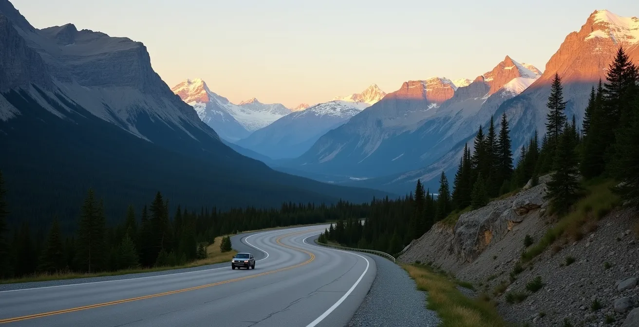
Reversing the loop direction to avoid tour bus traffic in the morning
One of the most effective strategies for enhancing your Golden Triangle experience is also the simplest: reverse the conventional route. Most travelers and virtually all large tour buses depart from the hubs of Banff and Lake Louise between 8 AM and 9 AM, heading west towards Golden or south into Kootenay. By starting your day in Golden and driving east, you execute a brilliant tactical maneuver against the flow of traffic.
This “reverse loop” strategy offers two immense benefits. First, you get the best possible morning light for photography. As you drive east, the rising sun is behind you, perfectly illuminating the massive western faces of the Rocky Mountains. This golden hour light creates breathtaking depth and colour, turning great photos into epic ones. In contrast, those driving west in the morning are often shooting directly into the sun or dealing with heavily shadowed mountain faces.
Second, and just as important, you experience the main attractions in near solitude. You can arrive at key Kootenay highlights like Sinclair Canyon and Radium Hot Springs well before the crowds arrive from the east mid-morning. This allows for a much more peaceful and personal experience at places that can feel overrun by midday. The empty road ahead of you in the morning is a stark and welcome contrast to the conga line of RVs and buses you’ll see heading in the opposite direction.

This strategic decision transforms the entire feel of your drive. Instead of competing for space at every pullout, you are free to immerse yourself in the landscape. It’s a simple shift in planning that pays massive dividends in both tranquility and photographic opportunities, making it a cornerstone of a well-executed Rockies itinerary.
Banff vs. Jasper peaks: where are the crowds thinner in August?
August in the Canadian Rockies is peak season, and the crowds can be intense, particularly in Banff National Park. With Banff welcoming more than four million people a year, popular trails can feel more like city sidewalks than mountain paths. For those seeking solitude and a more intimate connection with nature, blindly following the most famous trail recommendations is a recipe for disappointment. The key is to look beyond Banff’s main attractions and explore the equally stunning, yet significantly less crowded, peaks in Yoho and Kootenay National Parks.
While trails around Lake Louise and Moraine Lake are world-famous, Yoho’s Iceline Trail or Paget Peak offer comparable world-class alpine views with a fraction of the foot traffic. Similarly, Kootenay holds hidden gems like the Stanley Glacier and Floe Lake trails, which see minimal crowds even in the heart of August. The visual payoff is immense, but the experience is far more serene.
Another powerful strategy is “shoulder-hour hiking.” Instead of starting a popular hike like Banff’s Tunnel Mountain at 10 AM with everyone else, plan your ascent for late afternoon. A 6 PM start can reward you with a sunset summit in relative solitude, an experience the morning crowds will never have. This requires proper preparation—headlamps, extra layers, and bear spray are mandatory for evening hikes—but the reward is an unparalleled sense of peace. For ultra-popular spots like Moraine Lake, where personal vehicle access is now prohibited, your only options are booking the Parks Canada shuttle (often 48 hours in advance) or opting for a beautiful, car-accessible alternative like Emerald Lake in Yoho.
Strategy for Finding Solitude in August
- Prioritize trails in Yoho and Kootenay National Parks over those in the immediate Banff/Lake Louise area.
- Embrace “shoulder-hour hiking” by starting popular trails late in the afternoon for sunset views and fewer people.
- Check recent trail reviews on apps like AllTrails to gauge current crowd levels before committing to a hike.
- If you must visit Moraine Lake, be prepared to book the Parks Canada shuttle the moment tickets are released.
- Consider equally beautiful, drive-up alternatives like Emerald Lake and Takakkaw Falls in Yoho to avoid reservation-based logistics.
When to start driving to beat the Columbia Icefield bus tours?
The Columbia Icefield is a jewel of the Icefields Parkway, and consequently, a major hub for tour bus activity. Beating these crowds requires a disciplined, early-morning start. The large tour groups typically begin arriving from Banff and Jasper around 10 AM, and the area can become extremely congested by late morning. To experience the grandeur of the Athabasca Glacier without the masses, you must be on the road well before the sun is high in the sky.
The strategic imperative is to be at the Icefield Discovery Centre no later than 9 AM. This means departing from Lake Louise or Jasper by 7:30 AM at the latest. An early start not only allows you to secure a spot on one of the first glacier tours of the day but also provides a more peaceful drive along the parkway itself. You’ll have the viewpoints and pullouts largely to yourself, able to savour the stunning scenery without jostling for a parking spot. The traffic volume in peak summer is no small matter; on busy weekends, the highway surpasses 30,000 vehicles a day. Starting early is your best defense against this congestion.
The same logic applies to other high-demand locations. The situation at Moraine Lake, where private vehicle access has been prohibited, serves as a case study in crowd management. Access is now entirely dependent on securing a coveted spot on the Parks Canada shuttle, often at the 6:30 AM slot, which requires booking well in advance. This logistical challenge underscores a key principle of modern Rockies travel: for the most iconic spots, spontaneity is no longer an option. Meticulous advance planning or choosing less-trafficked (but equally beautiful) alternatives like Emerald Lake in Yoho is the new reality.
Whether it’s the Icefields or another popular destination, the rule is the same: the earlier, the better. Sacrificing an hour of sleep in the morning buys you hours of tranquility and unfettered access to some of the most spectacular landscapes on Earth. It’s a trade-off that is always worth making.
Key Takeaways
- Logistical planning for fuel and no-service zones is as crucial as planning your sightseeing stops.
- Reversing the standard loop direction is the single best strategy to avoid tour bus traffic and get better morning light.
- Wildlife safety is a serious responsibility; know the high-risk times (dusk/dawn) and have an emergency plan.
Hiking Rocky Mountain Peaks: Safety Protocols for High-Altitude Trails
The call of the alpine is strong in the Rockies, but answering it requires more than just a good pair of boots. It demands a deep respect for the mountain environment and strict adherence to safety protocols. You are entering a wild space where conditions can change in an instant and help can be hours away. Being prepared is not optional; it is a fundamental responsibility. As Parks Canada reminds visitors, you are entering the animals’ habitat, and your goal is to make as little impact as possible while ensuring your own safety.
As Parks Canada states in their official guidelines:
When visiting the park, please remember that you are visiting the animals’ habitat. Their continued health and survival relies on us making as little impact on their home as possible.
– Parks Canada, Jasper National Park Wildlife Guidelines
The single most important piece of equipment is bear spray. You must carry it, know how to use it, and have it accessible at all times—not buried in your backpack. Many areas, particularly around Moraine Lake during peak grizzly season, have legally mandated group size requirements (hiking in groups of 4 or more) for this reason. Always check the Parks Canada Trail Condition Reports before every single hike for closures, warnings, and current wildlife activity. For spring or early summer hikes, verifying avalanche conditions on the Avalanche Canada website is equally critical. Finally, since most trailheads have zero cell coverage, downloading offline maps and carrying a satellite messenger like a Garmin inReach or ZOLEO is a vital lifeline.
Your Pre-Hike Safety Audit
- Points of Contact: Save the Parks Canada Dispatch number (403-762-1470) and inform a trusted contact of your detailed trip plan using a service like AdventureSmart.
- Gear Inventory: Confirm you have bear spray (accessible), a satellite messenger, fully downloaded offline maps, and a first-aid kit.
- Condition Check: Cross-reference your planned route against the latest Parks Canada Trail Condition Report for any closures or wildlife warnings. Check Avalanche Canada if snow is present.
- Risk Assessment: Acknowledge specific risks for your chosen trail (e.g., mandatory group sizes for grizzly activity) and confirm you meet all requirements.
- Final Plan: File your trip plan, confirm your start time allows for a safe return before dark, and do one last check of the weather forecast.
By treating your Golden Triangle road trip with this level of strategic preparation, you move beyond the role of a mere tourist and become a savvy explorer, ready to unlock the very best of the Canadian Rockies. To put these strategies into practice, the next logical step is to build your personalized day-by-day itinerary based on these core principles of safety and efficiency.